


Contents
Component D: Project management, communication, and M&E (US$2 million)
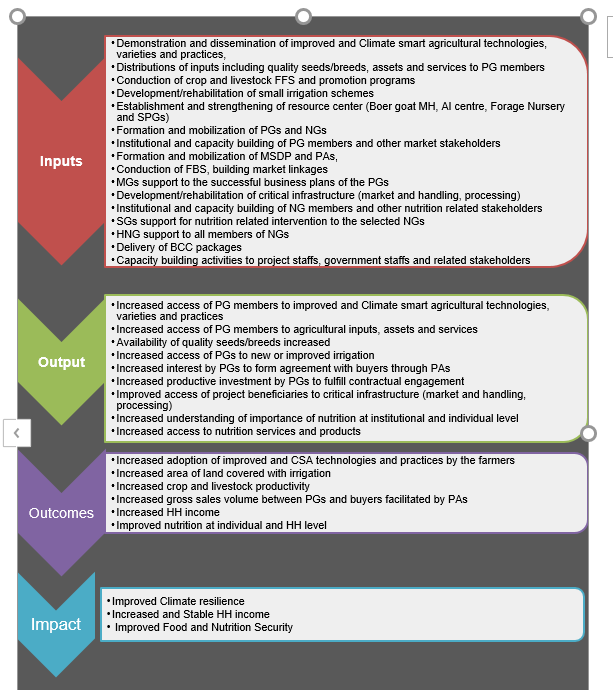
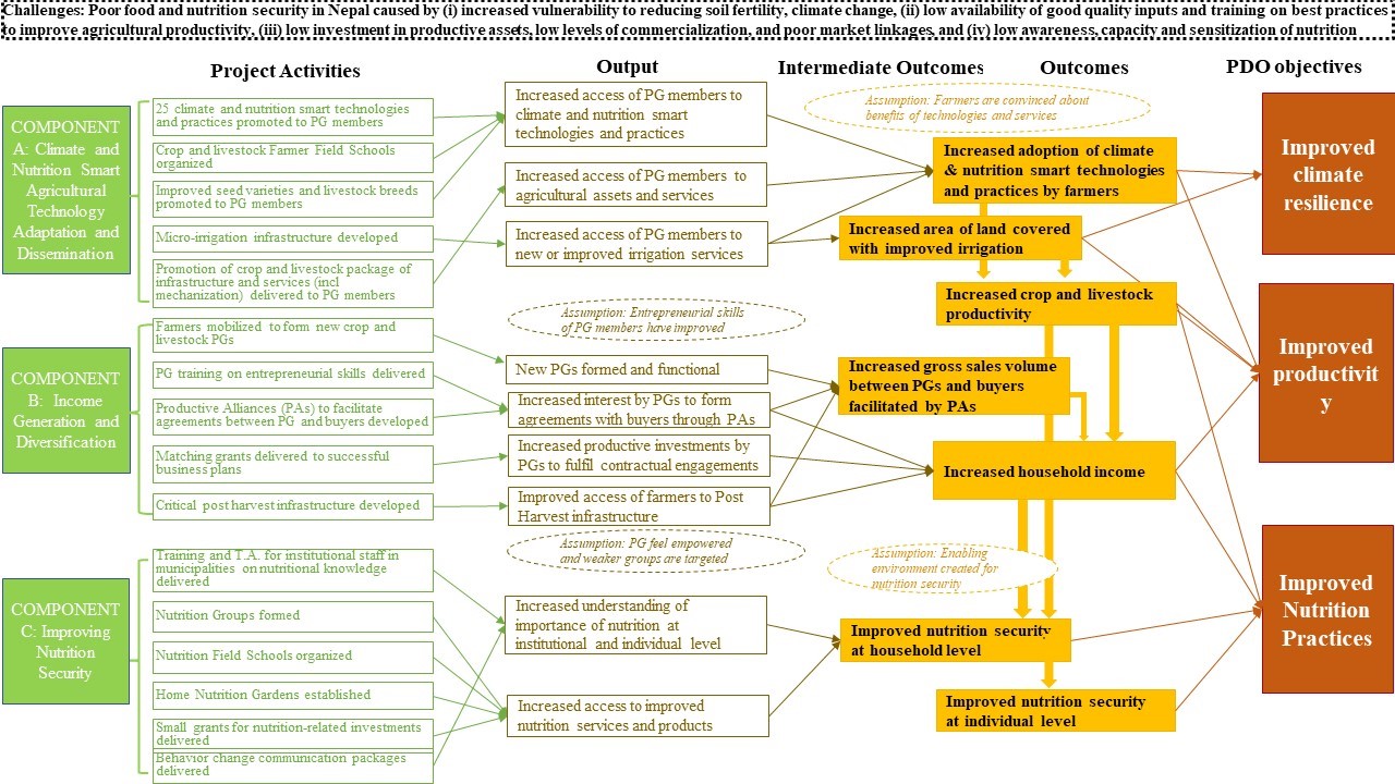
25. This component will support monitoring and reporting of implementation progress leveraging the M&E and Project Management Information System (PMIS) developed by FANSEP. In addition, this component will support: (a) compliance with the World Bank’s fiduciary and safeguard requirements; (b)interagency coordination; (c) experience sharing among beneficiary groups; (d) grievance management;(e) knowledge management and learning among project stakeholders; and (f) day-to-day operations of the Project Management Unit (PMU) and Project Cluster Units (PCUs). The manuals, strategies, and guidelines produced by the ongoing project for selection and award of matching and small grant schemes,implementation of FFSs, FBSs, and NFSs, livestock promotion programs (goat, dairy, and poultry), selection and award of mechanization support, and selection and construction of infrastructural activities such as collection centers, irrigation schemes, markets, and processing centers will be used by the project, with amendments, as needed.
-
Component C: Improving Nutrition Security (US$4.8 million)
22. This component will support nutrition-related interventions that are expected to systemically
address the underlying causes of malnutrition, through the following subcomponents:
Subcomponent C1: Institutional Capacity Strengthening
23. This subcomponent will engage in capacity building of 16 RMs to entrench, sustain, and advocate for improved nutrition and climate resilience outcomes in their communities. This subcomponent will provide capacity building for political leadership, bureaucracy, and/or program/technical leadership responsible for agriculture and livestock development and health and nutrition at the municipalities and for established ward- and local-level Nutrition and Food Security
Steering Committees. Where ward- and local-level Nutrition and Food Security Steering Committees are not constituted, the project will advocate with the abovementioned stakeholders of the municipalities to constitute and make these committees functional. The subcomponent will provide support in the following areas: (a) orientation on the Government’s current Multi-Sector Nutrition Plan (MSNP) II and MSNP III (pending approval of the Cabinet) through annual orientation sessions for stakeholders mentioned above; (b) advocacy and technical support for prioritization of a defined package of nutrition related investments in annual work plans and budgets and securing resources from the Multi-Sectoral Nutrition Program to implement the same; and (c) selection of municipalities on a pilot basis to conduct a minimum service standards review for health posts/primary health care facilities to assess readiness for delivery of the prescribed of health and nutrition services and to advocate during annual stakeholder orientation sessions, with an evidence-based approach, for resources through conditional grants to ensure such services to communities.
Subcomponent C2: Nutrition Field School (NFS) and Home Nutrition Gardens (HNGs)
24. This subcomponent will support the newly constituted 650 nutrition groups from 16 RMs, with exclusive participation of women of reproductive age (preference will be given to pregnant and nursing women and mothers of children 0–2 years of age) and beneficiaries from schools, to (a) participate in at least 128 NFSs; (b) establish 650 HNGs; and (c) access 400 small grants. Each of these activities will be complemented with a strong social and behavior change communication package to improve the production and consumption of nutritious and diverse foods at the household level. The allocation of small grants will be based on demand and implemented as per small grant guidelines, but with contributions from the groups in kind only. Cash contributions will be sought only in cases where contribution in kind is not feasible. Associated technical support to establish and maintain these grants will be provided, where relevant. In addition to the crops and breed interventions of the ongoing project, the NFSs and HNGs will also promote local nutritious and neglected crops. The existing package of social and behavior change communication for improved maternal, infant, and young child nutrition behaviors on will be reviewed and updated to respond appropriately to the nuanced needs of the established nutrition groups. Where feasible, nutrition gardens will also be established in schools of participating communities.
-
B. Project Components
15. The following four interrelated components of the ongoing project will be maintained: (A)Climate and Nutrition Smart Agricultural Technology Adaptation and Dissemination, (B) Income
Generation and Diversification, (C) Improving Nutrition Security, and (D) Project Management,
communication, and monitoring and evaluation (M&E).
Component A: Climate and Nutrition Smart Agricultural Technology Adaptation and Dissemination
(US$7.8 million)
16. This component will focus on promotion of best practices and technologies such as climate resilient,crop varieties and livestock breeds, climate-smart technology, and husbandry practices in the 16 new RMs. The interventions under Component A will be delivered through producer groups (PGs) formed under Component B.
Subcomponent A1: Technology Adaptation and Testing
17. Through this subcomponent, the proposed project will support the implementation of 25 improved climate- and nutrition-sensitive technologies and associated practices identified collaboratively with the Nepal Agricultural Research Council (NARC) in the project municipalities by FANSEP. Additionally, ready-to-roll out technologies and cultivars developed by NARC for the agroecological conditions similar to the project target areas, or the Consultative Group on International Agricultural Research, may be considered with priorities to technologies that enhance climate-resilient production systems and livelihoods. Key activities to be supported under this subcomponent will include:
(a) on-farm demonstration of CSA technologies and practices; (b) provision of improved seeds and breeds that were validated in the local context in FANSEP; and (c) trainings relevant to such demonstrations and distributions.
Subcomponent A2: Technology Dissemination and Farmers’ Skill Development
18. This component will implement activities that enable farmers to master the management skills (improved agriculture practices) to achieve climate resilience and mitigation. The activities will be implemented throughout the project area covering all 16 RMs. Key activities under this subcomponent will include: (a) conducting of 485 crop and livestock FFSs; (b) establishment of 16 artificial insemination (AI) units; (c) establishment of 8 goat multiplier herds; (d) establishment of 16 community-level fodder nurseries supporting plantations covering 320 ha; (e) promotion of community seed programs resource for improved seed replacement rate through establishment of 16 community-based seed production groups; (f) 325 crop promotion programs; and (g) 300 goat promotion programs, 120 dairy promotion
programs, and 60 rural poultry promotion programs. Further, through this subcomponent, the project will support 400 small-scale irrigation schemes covering 1,200 ha,8 including conservation of intake sites
(spring sheds) to capture and store runoff water and arrest soil erosion in project RMs, and provide
mechanization support to 300 PGs across the project area, with prioritized access for women producers.
Component B: Income Generation and Diversification (US$5.4 million)
19. This component will support selected PGs in diversifying their income generation capacity through
critical business skills, productive assets and value-added activities, and market linkages.
Subcomponent B1: Strengthening Producer Groups (PG)
20. The subcomponent will form and mobilize 1,350 new PGs (725 crop and 625 livestock) and build their capacity and entrepreneurial skills. These groups will receive trainings in group dynamics,leadership, decision-making, problem solving, risk management, preparation of business plans,bookkeeping, crop planning, and simple operation and maintenance of farm equipment. Given the successful pilot in FANSEP, 32 new FBSs will be conducted.
Subcomponent B2: Building Market Linkages through Productive Alliances9
21. This subcomponent will consolidate links between producer organizations and buyers including micro, small, and medium enterprises; traders; and rural financial institutions (where feasible) through Productive Alliances by financing business plans to meet the goals of the agreement with buyers. The activities financed under this subcomponent are: (a) around 720 matching grant10 schemes for targeted beneficiaries to finance the business plans developed under Subcomponent B1; and (b) formation of 16 multi-stakeholders’ dialogue platforms at the RM level. The matching grant schemes will be provided and implemented following the grant operating guidelines formulated under FANSEP. The eligibility criteria will include a financially and technically sound business plan including proposed activities; operational, environmental, and social risks and mitigation measures; potential to enhance beneficiaries’ climate resilience and adaptation; and potential to achieve climate change mitigation (for example, introducing energy-efficient facilities). The dialogue platforms are expected to provide opportunities for the buyers, producers, and service providers to meet, interact, and explore business opportunities. In addition, around 32 critical infrastructures to support the strengthening of the Productive Alliances in the project
8 Most irrigation schemes supported cover less than 1 ha of land.
9 A Productive Alliance is defined as an agreement between a group of organized farmers and a buyer, for the provision of a
certain good, in a specified quantity and quality.
10 Up to 15 percent contribution from the PGs, mostly in kind. RMs such as collection centers, storage, markets, and processing and grading facilities will be established to strengthen the supply chain and reduce postharvest losses. The designs of these infrastructure will be based on climate-resilient approaches ensuring they do not generate negative externalities or generate potential adverse effects on the environment and public health.
- Rural Poultry Promotion Program
- Goat Production Promotion Program
- Dairy Production Promotion Program
- Farmer Field School (Crops,Vegetables, livestock)
- Farmer managed boer goat multiplier herd/unit establishment
- Establishment of AI unit in Program implemented RMs for breed improvement
- Development of Climate Smart Agriculture (CSA), mechanization, management of pesticides/chemicals and other relevant technologies from NARC.
- Distribution of foundation seeds (Crops, Vegetables, Grass) for seed multiplication at farmer’s level.
- Distribution of improved seeds (Crops, Vegetables, Pulses) for production and productivity improvement
- Skill enhancement Trainings, orientation and visits to lead farmers and farmer groups
- Validation trails and technology demonstration at farmer's level.
| Province | PCU | District | FANSEP RM | FANSEP-II RM |
| Madhesh Province | Dhanusha
| Dhanusha | Mukhiapatti Musharniya and Dhanauji | Bateshwor and Janak Nandini |
| Mahottari | Pipara and Ekdara | Samsi and Sonama | ||
| Saptari
| Saptari | Rajgadh and Bishnupur | Chhinamasta and Mahadeva | |
| Siraha | Aurahi and Bariyarpatti | Nawarajpur and Laxmipur Patari | ||
| Gandaki Province | Gorkha | Gorkha | Barpak sulikot and Gandaki | Aarughat and Sahid Lakhan |
| Bagmati Province | Gorkha | Dhading | Benighat Rorang and Gajuri | Siddhalek and Galchi |
| Sindhupalchowk | Sindhupalchowk | Lisankhu pakhar and Indrawati | Sunkoshi and Tirpurasundari | |
| Dolakha | Kalinchok and Tamakoshi | Melung and Baiteshwor |
- Earthquake affected districts (4): Gorkha, Dhading, Sindhupalchowk and Dolakha.
- Flood affected districts (4): Siraha, Saptari, Dhanusha, Mahottari.
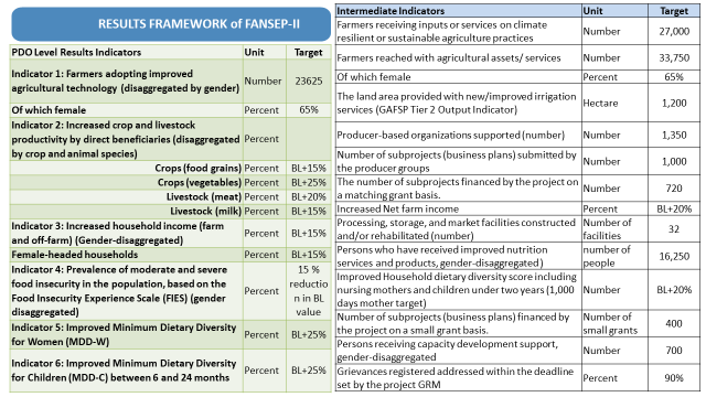
The PDO of FANSEP is to " enhance climate resilience, improve agricultural productivity and nutrition practices of targeted smallholder farming communities in selected areas of Nepal."
आयोजना क्लष्टर इकाई, सिन्धुपाल्चोक
खाद्य तथा पोषण सुरक्षा सुधार आयोजना अन्तर्गत भुकम्प प्रभावित जिल्लाहरु मध्येको दोलखा र सिन्धुपाल्चोकमा रहने गरि स्थापित आयोजना क्लस्टर इकाईको (PCU) कार्यालय सिन्धुपाल्चोकमा २०७६ साल जेष्ट महिनामा स्थापना भएको हो।आयोजनाका कार्य सम्पादनमा सहजता, तिव्रता र अनुगमन प्रभावकारी बनाउन २०७६ कार्तिकबाट यस आयोजनको PCU अन्तर्गतको एक सम्पर्क इकाई दोलखा जिल्लाको चरिकोटमा समेत स्थापना भएको छ।संयुक्त फिल्ड स्तरीय अध्ययनमा आधारित प्रतिवेदनको निष्कर्ष अनुसार यस आयोजनाको प्राविधिक समन्वय समितिको सिफारिसमा आयोजना निर्देशक समिति (Project Steering Committee) को मिति २०७६/०५/२५ गते वसेको वैठकको निर्णयअनुसार आयोजनाले सिन्धुपाल्चोक जिल्लाको स्थानिय तह ईन्द्रावति गाउँपालिका र लिसंखुपाखर गाउँपालिका साथै दोलखा जिल्लाको कालिन्चोक गाउँपालिका र तामाकोशी गाउँपालिकालाई आफ्नो कार्यक्षेत्र बनाएको छ ।यस क्लस्टर इकाईमा आयोजनाका गतिविधि संचालन गर्न नेपाल सरकारका कर्मचारिहरु आयोजना क्लष्टर इकाईमा रहेर अनुगमन कार्यक्रम र बजेट संचालनको जिम्मेवारिका साथ त्यस्तै गरि खाद्य तथा कृषि संगठन (FAO) बाट कृषि, पशुपंछी र पोषण बिज्ञ गरि तिन जना बिषय बस्तुको जानकारी गराउन आयोजना क्लष्टर इकाईमा रहने गरि र स्थानिय सेवा प्रदायक संस्थाबाट प्रत्येक पालिकामा ६।६ जना (कृषि तर्फ २ जना, पशुपंछी पालन तर्फ २ जना र पोषण तर्फ काम गर्ने २ प्राविधिकहरु) स्थानिय तहका सम्बन्धित शाखा संगको समन्वयमा फिल्डमा काम गर्ने गराउने जिम्मेवारी सहितको संरचनामा आबद्ध रहेर काम गर्ने छ।
आयोजना लागु भएका जिल्लाहरु
सिन्धुपाल्चोक
काठमाण्डौंबाट पिच सडकबाट जोडिएको र कोटेश्वरबाट २ घण्टा ४५ मिनेटको दुरीमा
सर्ब साधारणका लागी बस तथा माइक्रोबसहरु जिल्लाका मुख्य स्थान सम्म नियमित चल्ने गरेको छ।
पूर्वमा दोलखा र चिनको स्वसाशित क्षेत्र तिब्बतको केहि भू-भाग, पश्चिममा रसुवा, नुवाकोट र काठमाण्डौं, उत्तरमा रसुवा र चिनको स्वसाशित क्षेत्र तिब्बतको केहि भू-भाग तथा दक्षिणमा काभ्रेपलान्चोक, काठमाण्डौं र रामेछाप संग यस जिल्लाको सिमाना जोडिएको छ।
मेलम्चि, हेलम्बु, तातोपानी नाका, बाह्रविसे, मुढे, मुढेको आलु, जुगल हिमाल, पाँचपोखरी, गौराति मेला तातोपानि स्नान, भोटेकोशी, बन्जि जम्पिङ्ग, सुकुटे बिच, ईन्द्रावति नदि आदि शब्दावलीहरुले यस जिल्लाका विविध पक्षपक्षका बिषेशतालाई समेटेको छ।
जिल्लाको बिषेश भूगोलमा धान, मकै, कोदो, मास, दुध, लप्सि, अदुवा, लहसुन, ताजा तरकारी तथा बाख्रापालन जस्ता कृषि र पशुपंछी जन्य उपजको उत्पादन राम्रो हुने गरेको।
चिनको स्वसाशित क्षेत्र तिब्बतसंग (लिपिङ्गमा) नाका रहेको।
दोलखा
काठमाण्डौंबाट पिच सडकबाट जोडिएको र कोटेश्वरबाट ४ घण्टा ३० मिनेटको दुरीमा
सदर मुकाम चरिकोटबाट तामाकोशी, मन्थलि खुर्कोट हुँदै करिब ५ घण्टामा बर्दिबास तराई क्षेत्र सम्म पुग्न सकिने सडक संजाल समेत रहेको छ।
सर्ब साधारणका लागी बस तथा माइक्रोबसहरु राजधानिबाट जिल्लाका मुख्य स्थान सम्म नियमित चल्ने गरेको छ।
पूर्वमा सोलुखुम्बु र रामेछाप, पश्चिममा सिन्धुपाल्चोक र चिनको स्वसाशित क्षेत्र तिब्बतको केहि भू-भाग, उत्तरमा चिनको स्वसाशित क्षेत्र तिब्बत र दक्षिणमा रामेछाप तथा सिन्धुली संग यस जिल्लाको सिमाना जोडिएको छ।
चरिकोट, सैलुङ्ग, खरिढुंगा, जिरि, अपर तामाकोसी, गौरी शंकर, छ्यो रोल्पा, कालिन्चोक, दोलखा भिमसेन, फिल्म सिटि, लामाबगर नाका तथा सिंगटि आदि शब्दावलीहरुले यस जिल्लाका विविध पक्षका बिषेशतालाई समेटेको छ।
जिल्लाको बिषेश भूगोलमा धान, मकै, कोदो, फापर, दुध, अदुवा, लहसुन, अमिलो जातका फलफूल, किवि, अलैंचि, चौंरि पालन तथा बाख्रापालन जस्ता कृषि र पशुपंछी जन्य उपजको उत्पादन राम्रो हुने गरेको।
चिनको स्वसाशित क्षेत्र तिब्बतसंग (लामाबगर क्षेत्रमा) आवतजावत नाका रहेको।
आयोजना लागु भएका गाउँपालिकाहरुको परिचय
|
क्र.स. |
पालिका |
क्षेत्रफल (वर्ग किलो मिटर) |
सिमाना |
कृषि योग्य जमिन (हेक्टर) |
सिंचाई सुविधा |
मुख्य उत्पादन |
उत्पादनका समस्या |
|
१ |
ईन्द्रावती |
१०५.११ |
पूर्वमा चौतारा सांगुरीगढी न.पा. र जुगल गा.पा., पश्चिममा मेलम्चि न.पा., उत्तरमा पाँचपोखरी थाङ्गपाल गा.पा. र जुगल गा.पा. तथा दक्षिणमा काभ्रेपलान्चोक जिल्ला। |
४११५ |
वडा ७, ८ र ९ का केहि स्थान बाहेक अन्य स्थानमा जटिल |
धान, गहुँ, मकै, कोदो, लप्सि, अदुवा, लसुन, ताजा तरकारी र पशुपालन |
सिंचाई, जंगलि जनावर र न्यून श्रमशक्ति |
|
२ |
लिसंखुपाखर |
९८.६१ |
पूर्वमा रामेछाप र दोलखा जिल्ला, पश्चिममा सुनकोशी गा.पा., उत्तरमा त्रिपुरा सुन्दरी गा.पा. तथा दक्षिणमा काभ्रेपलान्चोक जिल्ला र सुनकोशी गा.पा.। |
२८७० |
अधिकांश स्थानमा जटिल |
आलु, ताजा तरकारी, कोदो र पशुपालन |
सिंचाई, जंगलि जनावर र न्यून श्रमशक्ति |
|
३ |
कालिन्चोक |
१३२.४९ |
पूर्वमा गौरिशंकर गा. पा., पश्चिममा सिन्धुपाल्चोकको त्रिपुरा सुन्दरि गा.पा. र बाह्रविसे न. पा., उत्तरमा विगु गा.पा. तथा दक्षिणमा भिमेश्वर न. पा. र बैतेश्वर गा.पा.। |
४५७९ |
वडा ६, ७, ८ र ९ का केहि स्थान बाहेक अन्य स्थानमा जटिल |
अमिलो जातका फलफूल, धान, मकै, कोदो, किवि, आलु, अलैंचि र पशुपालन |
सिंचाई, जंगलि जनावर र न्यून श्रमशक्ति |
|
४ |
तामाकोसी |
१५३.०६ |
पूर्वमा रामेछाप जिल्ला, पश्चिममा मेलुङ्ग र शैलुङ्ग गा.पा., उत्तरमा बैतेश्वर गा.पा. र जिरी न. पा. तथा दक्षिणमा रामेछाप जिल्ला। |
४२४५ |
वडा ३, ४ र ६ का केहि स्थान बाहेक अन्य स्थानमा जटिल |
धान, गहुँ, मकै, कोदो, अदुवा, लसुन, ताजा तरकारी र पशुपालन |
सिंचाई, जंगलि जनावर र न्यून श्रमशक्ति |
|
क्र.स. |
पालिका |
वडा संख्या |
आयोजना संचालित वडा |
घरधुरी |
जनसंख्या |
जम्मा |
पालिका कार्यालय रहेको स्थान |
|
|
|
|
|
|
|
पुरुष |
महिला |
|
|
|
१ |
ईन्द्रावती |
१२ |
१, २, ३, ४, ५, ६, ७, ८ र ९ |
६२११ |
१५१४१ |
१३३७६ |
२८५१७ |
ईन्द्रावति ४, नवलपुर |
|
२ |
लिसंखुपाखर |
७ |
सबै |
३६८० |
८०३२ |
७१११ |
१५१४३ |
लिसंखुपाखर ४, अत्तरपुर |
|
३ |
कालिन्चोक |
९ |
सबै |
५४५७ |
१२००८ |
१०९४६ |
२२९५४ |
कालिन्चोक ८ सुनखानी (हालको) र कालिन्चोक ६ लापिलाङ्ग (प्रस्तावित) |
|
४ |
तामाकोशी |
७ |
१,३, ४, ५ र ६ |
४३४६ |
१०००३ |
८७७६ |
१८७७९ |
तामाकोशी ३, जफे |
|
क्र.स. |
पालिका |
जातिय बिषेशता |
मुख्य ब्यापारिक स्थान |
यातायात/संचार/बिजुली |
|
|
|
|
|
|
|
१ |
ईन्द्रावती |
तामाङ्ग, ब्राम्हण, क्षेत्री, दलित, नेवार, शेर्पा र दनुवार |
मेलम्चि, नवलपुर, कुन्ता, चौतारा, बाहुनेपाटी र सिपाघाट |
पालिका रहेको स्थान सम्म ग्राभेल सडक मेलम्ची र चौताराबाट पुगेको छ। अन्य बडाको मुख्य स्थान सम्म समेत कच्चि सडक पुगेको छ। साथै संचार र बिजुली अधिकांस मुख्य बस्तिमा पुगेको छ । |
|
२ |
लिसंखुपाखर |
तामाङ्ग, ब्राम्हण, क्षेत्री, दलित, नेवार र शेर्पा |
शिलढुंगा, पाखर, मुढे र खाँडिचौर |
पालिका रहेको स्थान सम्म चौताराबाट नै पिच ग्राभेल सडक पाखर र शिलढुंगा हुंदै पुगेको छ। अन्य बडाको मुख्य स्थान सम्म समेत कच्चि सडक पुगेको छ। साथै संचार र बिजुली अधिकांस मुख्य बस्तिमा पुगेको छ । |
|
३ |
कालिन्चोक |
थामि, ब्राम्हण, क्षेत्री, शेर्पा , नेवार र दलित |
सिंगटी, चरिकोट र सुनखानि |
पालिका रहेको स्थान सम्म चरिकोटबाट नै पिच ग्राभेल पुगेको छ। अन्य बडाको मुख्य स्थान सम्म समेत कच्चि र ग्राभेल सडक पुगेको छ। साथै संचार र बिजुली अधिकांस मुख्य बस्तिमा पुगेको छ । |
|
४ |
तामाकोशी |
माझि, सुनुवार, भुजेल, नेवार, दलित, क्षेत्री र ब्राम्हण |
किर्ने, चरिकोट, जिरि र तामाकोशी |
पालिका रहेको स्थान सम्म चरिकोटबाट नै पिच ग्राभेल पुगेको छ। अन्य बडाको मुख्य स्थान सम्म समेत कच्चि र ग्राभेल सडक पुगेको छ। साथै संचार र बिजुली अधिकांस मुख्य बस्तिमा पुगेको छ । |
Project Cluster Unit, Saptari
Project Implemented District
- Saptari is a part of Province No. 2, is one of the seventy-seven districts of Nepal. Its district headquarter is Rajbiraj. Saptari is an Outer Terai district. This district covers an area of 1,363 km2 and has a population (2011) of 639,284 which makes it the 10th most populated district of Nepal.
Saptari is predominantly an agriculture-dependent district. Most of Saptari’s land is arable, and most of it (92,817ha) is cultivated. Saptari has experienced recurrent floods in the last few years, from Koshi, Khado, Mahuli, Sundari and Khadak rivers during every monsoon season. In addition to floods, earthquakes, accidental fires, cold waves, drought and epidemics also regularly occur in the district.
There are nine municipalities in Saptari: Dakneshwori, Rajbiraj, Bodebarsain, Hanumannagar Yoginimai, Kanchanrup, Saptakoshi, surunga, Shambhunath and Khadak and nine rural municipalities: Bishnupur, Rajgad, Chhinnamasta, Tilathi koiladi, Mahadeva, Agnisaira Krishna savaran, Tirhut, Balan- bihul, Rupani.
Project implemented Rural Municipalities
- Bishnupur is a rural municipality in Saptari District of south-eastern Nepal. At the time of the 2017 Nepal census it had a population of 23,035 people living in 6554 individual households. There are seven wards in rural municipality.
- Rajgadh is a rural municipality in Saptari District of south-eastern Nepal. At the time of the 2017 Nepal census it had a population of 29,459 people living in 8450 individual households. There are six wards in rural municipality.
- Siraha District is a district in Province No. 2, is one of the seventy-seven districts of Nepal. It is situated in the Terai belt of Nepal. The district, with Siraha as its district headquarters, covers an area of 1,188 km2. It has population of 637,328 according to census of 2011. When dividing Nepal into 34 districts, Siraha was in Saptadi district. Rajbiraj Airport is the nearest airport to the district, roughly 50-58 km away from various locations. Buddha airlines operates daily flights between Rajbiraj and Kathmandu.
The district consists of seventeen municipalities, out of which eight are urban municipalities and nine are rural municipalities. Eight municipalities are Lahan, Dhangadhimai, Siraha, Golbazar, Mirchaiya, Kalyanpur, Karjanha, Sukhipur and nine rural municipalities are Bhagwanpur, Aurahi, Bishnupur, Bariyarpatti, Lakshmipur patari, Naraha, Sakhuwanankar, Arnama, Navarajpur.
Project implemented Rural Municipalities
- Aurahi is a Rural municipality in Siraha District in Province No. 2 of Nepal. It was formed in 2016 occupying current 5 sections (wards). It occupies an area of 35.87 km2 with a total population of 23,046.
- Bariyarpatti is a Rural municipality in Siraha District in Province No. 2 of Nepal. It was formed in 2016 occupying current 5 sections (wards). It occupies an area of 37.72 km2 with a total population of 25,256.
Project Cluster Unit, Dhanusha
Project Implemented District
- Dhanusha District, a part of Province No. 2, is one of the seventy-seven districts of Nepal. Its district headquarter is Janakpur. It is an outer Terai district. This district covers an area of 1,180 km2 and has a population (2011) of 7,54,777.
Dhanusha is predominately an agriculture-dependent district of Nepal. More than two-third area (76,531 ha) of district is arable and only 45 % of this is irrigated. Dhanusha has experienced recurrent floods in the last few years, from Kamala, Balan, Bachharaja, and Charnath rivers mainly during every monsoon season. In addition to floods, earthquakes, accidental fires, cold waves, drought and epidemics also regularly occur in the district and are the major causes of food and nutrition insecurity of the people.
Project implemented Rural Municipalities
- Dhanauji is a Rural municipality in Dhanusha District in Province No. 2 of Nepal. It was formed in 2073 BS occupying current 5 sections (wards). It occupies an area of 22 km2 with a total population of 21,395.
- Mukhiyapatti Musharniya is a Rural municipality in Dhanusha District in Province No. 2 of Nepal. It was formed in 2073 BS occupying current 6 sections (wards). It occupies an area of 26.84 km2 with a total population of 25,482.
- Mahottari District, a part of Province No. 2, is one of the seventy-seven districts of Nepal. Its headquarter is located in Jaleshwar, a neighbouring town of the historical city of Janakpur. The name Jaleshwor means the ‘God in Water’. One can find a famous temple of Lord Shiva in Water there. Jaleshwar lies at a few kilometres distance from the Nepal-India border and has a majority Maithili population. The district covers an area of 1,002 km2 and has a population (2011) of 6,27,580. The total arable land of the district is 67,352 ha. Mahottari district also has experienced recurrent floods in the last few years, from Ratu, Bighi, Ankush and Maraha rivers mainly during every monsoon season. In addition to floods, earthquakes, accidental fires, cold waves, drought and epidemics also regularly occur in the district and are the major causes of food and nutrition insecurity of the people.
Project implemented Rural Municipalities
- Pipara is a Rural municipality in Mahottari District of Province No. 2, Nepal. It was established in 2073 BS occupying current 7 sections (wards). It occupies an area of 39.98 km2 with a total population of 35,524.
- Ekdara is a Rural municipality in Mahottari District of Province No. 2, Nepal. It was established in 2073 BS occupying current 6 sections (wards). It occupies an area of 24 km2 with a total population of 29,315.
Component A: Climate and Nutrition Smart Agriculture Technology Adaptation and Dissemination
- Subcomponent A1: Technology Adaptation and Testing
- Subcomponent A2: Technology Dissemination and Farmer Skills Development
Component B: Income Generation and Diversification
- Subcomponent B1: Strengthening Producer Groups
- Subcomponent B2: Market Linkages through Productive Alliances
Component C: Improving Nutrition Security
- Subcomponent C1: Institutional Capacity Strengthening
- Subcomponent C2: Nutrition Field School (NFS) and Home Nutrition Gardens (HNGs)
Component D: Project management, communication, and M&E
The Project will focus on 16 rural municipalities (RMs) of 8 districts of Nepal. Among the 8 project districts 4 are earthquake (2072) affected hilly districts and 4 are flood affected terai districts.
|
नाम |
पद |
इमेल |
शाखा |
फोटो |
|
सुकेश्वर झा |
ब.कृ.अ. |
sukeshwarjha123@gmail.com |
कार्यालय प्रमुख |
|
|
रघुनाथ महतो |
कृ.अ. |
|
प्राबिधिक/कृषि |
|
|
सुनिल कुमार चौधरी |
कृ.अ. |
sunilkchaudhary1990@gmail.com |
प्राबिधिक/कृषि |
|
|
बिष्णु देव महतो |
प्रा.स. (भेट.) |
mbishnudev@yahoo.com |
स्टोर/ पशुसेवा |
|
|
मुकुन्द ठाकुर |
कम्प्युटर अपरेटर |
mukundthakur98@yahoo.com |
|
|


|
सि.नं. |
नाम |
पद |
इमेल |
शाखा |
फोटो |
|
१
|
प्रदीप ठाकुर वरही |
वरिष्ट कृषि अधिकृत |
pradeeptakur@yahoo.co.in |
आयोजना क्लष्टर इकाई, सप्तरी |
|
|
२
|
विजय कुमार मण्डल(सुचना अधिकृत) |
कृषि प्रसार अधिकृत |
rajbijaya20@gmail.com |
|
|
|
३
|
विनय विक्रम रत्न(गुनासो सुन्ने अधिकृत) |
पशु विकास अधिकृत |
rbinaybikram@gmail.com |
|
|
|
४
|
मोहम्मद लतिफ |
प्रा.स(कृषि) |
|
|
|

|
नाम |
पद |
इमेल |
शाखा |
फोटो |
|
दुर्गा प्रसाद पण्डित |
बरिष्ठ कृषि अधिकृत |
fansep.gorkha@gmail.com |
कार्यालय प्रमुख |
|
|
लेखराज ढकाल |
कृषि अधिकृत |
योजना तथा समन्वय शाखा |
|
|
|
नारायण पौडेल |
कृषि अधिकृत |
|
प्राविधिक शाखा |
|
|
चिन्ता नारायण खनाल |
प्राविधिक सहायक |
narayanchintak@gmail.com |
प्राविधिक/प्रशासन शाखा |
|
|
प्रदिप पौडल |
लेखापाल |
Pradeeppaudel90@gmail.com |
लेखा शाखा |
|
|
बलदेब सिंह महरा |
प्राविधिक सहायक |
baldebdarchula11@gmail.com |
प्राविधिक शाखा |
|
|
दिपक खत्री |
हलुका सवारी चालक |
|
|
|
|
कान्छा गुरुङ |
कार्यलय सहयोगी |
|
|
|


Food and Nutrition Security Enhancement Project (FANSEP) is funded by Global Agriculture and Food Security Program (GAFSP). The grant agreement between Government of Nepal (GON) and International Development Association (IDA) for the FANSEP was signed on 1st December 2023. The total Project cost is 22 million USD of which 20 million USD is GAFSP grant and 2million USD is counterpart funding from GON. This project is implemented by Ministry of Agriculture and Livestock Development (MoALD), supervised by World Bank (WB) and Technical Assistance is provided by Food and Agriculture Organizations (FAO) of the United Nations. This project is implemented in 16 Rural Municipalities (RMs) of eight districts (Gorkha, Dhading, Sindhupalchowk, Dolakha, Dhanusha, Mahottari, Siraha and Saptari) for the duration of 3.5 years. The project aims to reach 55,000 direct beneficiaries.
Agriculture is a major driver of Nepal’s economy and the dominant source of employment. Food and Nutrition Security is multidimensional aspect and agriculture plays the main role for ensuring it. The constitution of Nepal has recognized the right to food as fundamental right of Nepalese citizen. The government of Nepal (GON) has formulated various national policies and programs and has also committed to various international agreement for ensuring food and nutrition security. The GON has committed to achieve the Sustainable Development Goals (SDGs). Similarly, achievement of Food and Nutrition Security has been given prime importance in GON national policies like; Vision 2100, 16th periodic plan and Agriculture Development Strategy (ADS). FANSEP compliments the Food and Nutrition Security Program of Agriculture Development Strategy which is one among its four flagship programs. Additionally, FANSEP plays direct role in achieving all the targets related to food and nutrition security set forward in all aforementioned government policies, ADS and international commitments like SDGs .
The PDO of FANSEP is to " enhance climate resilience, improve agricultural productivity and nutrition practices of targeted smallholder farming communities in selected areas of Nepal."
